Snow dump to 500m overnight

Grab your snow chains, cameras and hot chocolate - there's a big snow dump forecast for Queenstown Lakes tonight.
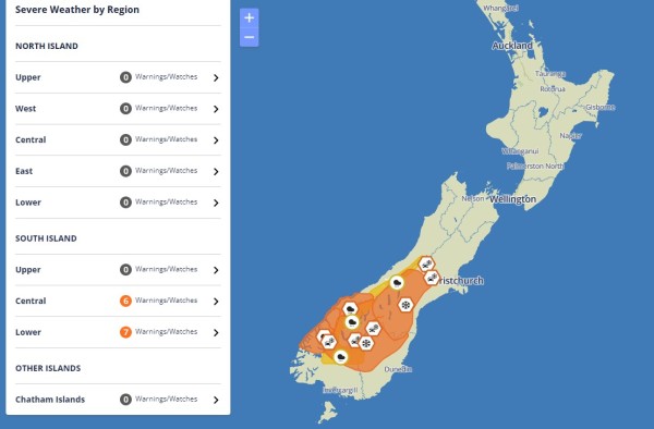
MetService has issued a Heavy Snow Watch for Central Otago and Queenstown Lakes District for 13 hours, from 6pm tonight to 7am Friday morning.
Its metrologists expect periods of heavy snow above 500m, where snowfall amounts may approach warning criteria. Queenstown, at lake level, is 330m in elevation. There's a moderate chance of the 'watch' being upgraded to a 'warning'.
"Prepare for snow, cold temperatures, and possible power outages," the MetService advice reads. "If you must travel, drive cautiously, and ensure you have snow chains, sleeping bags, warm clothing, and emergency items."
Travel disruption and damage to trees and powerlines is possible, and the cold conditions may cause stress for livestock.
That means, of course, there's also Road Snowfall Warnings for many of the South Island's alpine passes, including the Crown Range between Queenstown and Wānaka, for the same period.
"Rain is forecast to turn to snow Thursday evening. 3 to 8 cm of snow may accumulate above 700 metres, with lesser amounts down to about 500 metres," the warning reads.
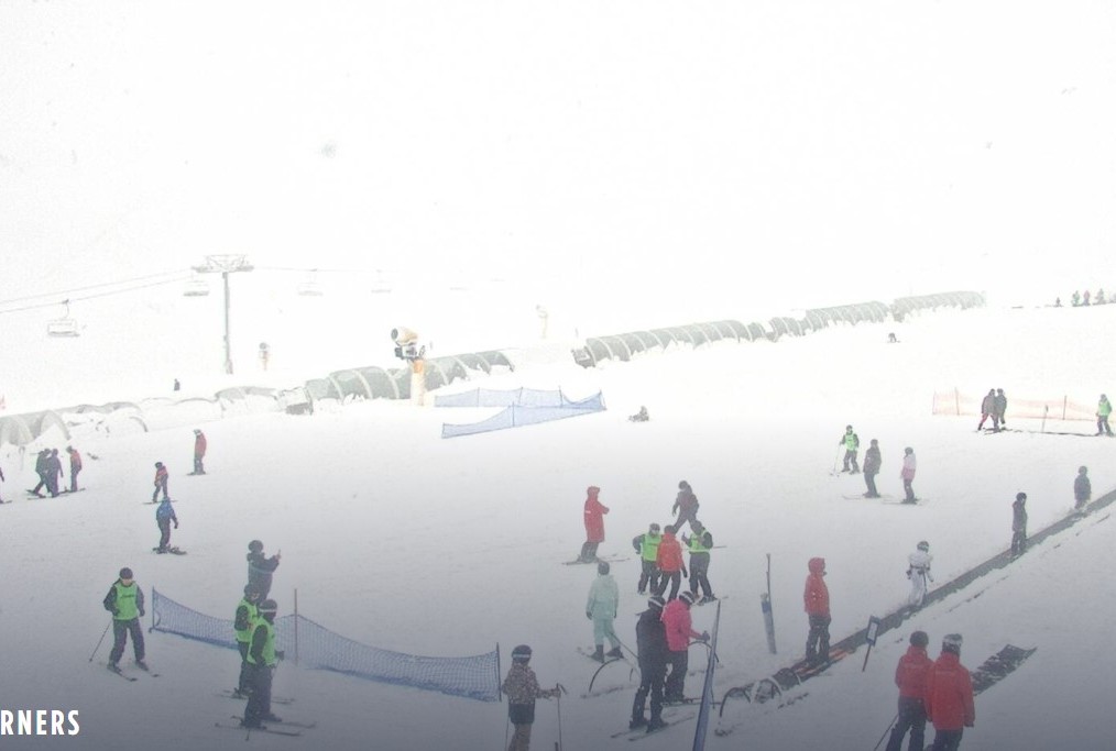
All this is great news for the skifields. The Remarkables has had more than 27cms in the past 48 hours and it was snowing heavily this morning, but the mountain was open. Coronet Peak had also had snow but this had turned to rain this morning, and the mountain is closed, so the coming dump will be welcome.
For all daily snow reports, including Cardrona Alpine Resort and Treble Cone, check the Queenstown App.
Check the MetService website for updates

Here are the rest of the MetService's weather watches and warnings for the South Island, as the front moves slowly northwards over the lower South Island today and Friday, preceded by moist northwesterlies and followed by a much colder southeast flow.
Heavy Rain Warning - Orange
Area: Westland District south of Haast
Period: 20hrs from 9am Thu, 12 Sep - 5am Fri, 13 Sep
Forecast: Expect 130 to 160 mm of rain. Peak rates of 15 to 25 mm/h expected during this afternoon. Minimal chance of upgrading to a Red Warning.
Impact: Streams and rivers may rise rapidly. Surface flooding, slips, and difficult driving conditions possible.
Action: Clear your drains and gutters to prepare for heavy rain. Avoid low-lying areas and drive cautiously. Preparedness advice.
Area: Fiordland from Doubtful Sound northwards
Period: 9hrs from 9am - 6pm Thu, 12 Sep
Forecast: Expect 90 to 120 mm of rain on top of what has already fallen. Peak rates of 15 to 25 mm/h expected during this morning. Minimal chance of upgrading to a Red Warning.
Impact: Streams and rivers may rise rapidly. Surface flooding, slips, and difficult driving conditions possible.
Action: Clear your drains and gutters to prepare for heavy rain. Avoid low-lying areas and drive cautiously. Preparedness advice.
Heavy Snow Warning - Orange
Area: Canterbury High Country south of the Rakaia River
Period: 12hrs from 3am - 3pm Fri, 13 Sep
Forecast: Expect 10 to 20 cm of snow to settle above 400 metres, with lesser amounts down to 300 metres. Minimal chance of upgrading to a Red Warning.
Impact: Travel disruption and damage to trees and powerlines possible. Cold conditions may cause stress for livestock.
Action: Prepare for snow, cold temperatures, and possible power outages. If you must travel, drive cautiously, and ensure you have snow chains, sleeping bags, warm clothing, and emergency items. Preparedness advice.
Area: Southland north of Lumsden, and Otago
Period: 15hrs from 5pm Thu, 12 Sep - 8am Fri, 13 Sep
Forecast: Expect 15 to 25 cm of snow to settle above 400 metres, with lesser amounts down to 300 metres. Minimal chance of upgrading to a Red Warning.
Impact: Travel disruption and damage to trees and powerlines possible. Cold conditions may cause stress for livestock.
Action: Prepare for snow, cold temperatures, and possible power outages. If you must travel, drive cautiously, and ensure you have snow chains, sleeping bags, warm clothing, and emergency items. Preparedness advice.
Heavy Rain Watch
Area: The ranges of the Westland District between Haast and Arthur's Pass.
Period: 18hrs from 3am - 9pm Fri, 13 Sep
Forecast: Periods of heavy rain, and amounts may approach warning criteria. Moderate chance of upgrading to a Warning.
Area: The Headwaters of the Otago lakes and rivers
Period: 12hrs from 9am - 9pm Thu, 12 Sep
Forecast: Periods of heavy rain. Rainfall amounts may approach warning criteria within 20 km east of the main divide. Note, rain turns to snow from the south this evening. Low chance of upgrading to a Warning.
Area: Southland north of Lumsden
Period: 8hrs from 9am - 5pm Thu, 12 Sep
Forecast: A period of heavy rain, and amounts may approach warning criteria. Moderate chance of upgrading to a Warning.
Issued: 9:26am Thu, 12 Sep
Next update: 9pm Thu, 12 Sep
Action advice supplied by the National Emergency Management Agency.
Road Snowfall Warnings
Area: Arthur's Pass (SH73)
Period: 17hrs from 7am - midnight Fri, 13 Sep
Forecast: Snow expected to start falling Friday morning. 1 to 3 cm may accumulate about the road above 500 metres, with lesser amounts down to about 400 metres.
Area: Porters Pass (SH73)
Period: 17hrs from 7am - midnight Fri, 13 Sep
Forecast: Snow expected to start falling Friday morning. 2 to 5 cm may accumulate about the road above 500 metres, with lesser amounts down to about 400 metres.
Area: Lindis Pass (SH8)
Period: 15hrs from 9pm Thu, 12 Sep - noon Fri, 13 Sep
Forecast: Rain is forecast to turn to snow Thursday night. 10 to 20 cm of snow may accumulate above 500 metres, with lesser amounts down to about 300 metres.
Area: Crown Range Road
Period: 14hrs from 7pm Thu, 12 Sep - 9am Fri, 13 Sep
Forecast: Rain is forecast to turn to snow Thursday evening. 3 to 8 cm of snow may accumulate above 500 metres, with lesser amounts down to about 400 metres.
Area: Milford Road (SH94)
Period: 6hrs from 7pm Thu, 12 Sep - 1am Fri, 13 Sep
Forecast: Rain is forecast to turn to snow Thursday evening. 1 to 3 cm may accumulate above about 800 metres.


