Hang onto your hats – El Nino is here!
We’ll be hanging onto our sunhats this spring, and bracing for some very hot days, possibly 30degC in October, as this year’s El Nino weather pattern bears down on Queenstown Lakes and Central Otago.
NIWA principal scientist forecasting and media Chris Brandolino says while Queenstown’s central positioning is a little harder to predict, the warm 100km/hr winds last month were typical of El Nino. This is often followed by heavy rain as was the case with the big electric storm here last month. “That week was a dress rehearsal for spring and summer,” he says.
While El Nino produces wetter in the west and hotter and windier in the east, the Wakatipu’s likely to see windier conditions, typical of spring.
“This spring is likely to produce wild swings in temperature. Air pressure in New Zealand, with its dominant westerlies, will leave the country more exposed than normal to dramatic swings in temperatures,” Brandolino says. “This variability will be expressed by spells of unseasonable warmth from Australian air masses and sharply colder southerlies flowing in behind, with little middle ground.”
Each El Nino has its own personality - 2015 produced a “quintessential El Nino” until January, with October temperatures reaching 30degC. “I’d be most surprised if we didn’t get 30degC this October,” Brandolino says.
However, strong westerly fronts may occasionally impact the western and lower South Island too, bringing heavy rain and flooding risks to the West Coast, inland Otago and Southland.
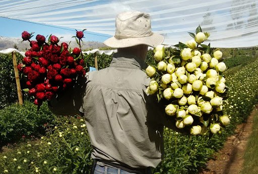
Bannockburn’s Carrick Peonies owner John Chambers says the emerging El Nino spring weather – predicted by some to be the worst in 60 to 80 years, is a bit concerning for growers.
“We’ve been told that apart from stronger, more frequent winds we could get temperatures into the late 20s this month (October) and if that occurs around our late October harvest, we can’t get the stems picked quickly enough,” Chambers says. “We had two 30degC back-to-back days during a similar El Nino weather pattern in 2015 and our season lasted 10 days to two weeks – half the normal time.”
He lost several thousand stems with only a brief 30-minute window before the buds turn in that kind of early heat. “I feel the way the weather pattern is heading at present that it will have some impact on us, but it’s too early to tell.”
It’s not only warmer daytime temperatures in spring that affect budding in his in-demand export quality flowers sent all over the world, but also warmer night-time temperatures expected during El Nino. During that hot October spell night-time temperatures didn’t fall below 10degC. They’re usually 3degC to 6degC.
“A flower can be not ready to pick then if it’s too hot in just 30 minutes it’s gone, and we can’t use it. Bud stage is quite critical to ensure the right quality when it lands with a florist in New York so it can affect our export production.” In reverse, he lost half of his 20,000 to 23,000 peonies during last year’s spring polar blast. “We are very dependent on weather. In 23 years, that was the worst,” he says.
The northwesterly gusts of 90km/hr on 20 September, followed by torrential rain, were a bit of a foretaste and while Chambers was mostly sheltered, another Central Otago grower reported some broken stems.
Rebecca Trotter, of Luggate’s Red Bridge Berries, says strawberries liked the cooler winter and they’re looking better than last year, although they have a smaller crop this year due to failed, storm-hit crops in the North Island. “They only produced 30% of normal production and that’s where we get all our plants from,” she says. Plant prices are really high as a result so Trotter’s hoping people will want to come pick their own.
Award-winning winemaker Grant Taylor, of Valli Wines, says buds aren’t even out yet and crop levels are usually set by flowering levels from the previous year. “It was such a good warm summer so we’re expecting good flowers, but anything can happen. You go with what you get. There’s nothing you can do to prepare for it.”
MetService forecaster Gerard Bellam predicts more of a swing to changeable westerly weather and less easterly for Queenstown Lakes-Central Otago now that El Nino is here. “Last year the south of the South Island was sheltered from fronts, but you can expect more fronts from the west now,” he says. However, El Nino is also likely to bring some very warm, hot spells ahead of those fronts. “You’ll probably be returning to a more normal spring. You’ve had less wind the last few years due to La Nina.”